Related pages
Why is geography important
In the Bible, many different physical locations are mentioned, and are often described in great detail. This goes to show to that the events in Bible were set in specific geographical locations, in real history. It is certainly not an imaginary account. The detailed descriptions of geography add authenticity to the Biblical account, giving it objective reality, giving us confidence that the events really happened. Geographical accuracy is a legitimate test of whether or not the Bible is the inspired word of God. All known geographical descriptions match their physical reality.
Events described in the Bible are affected by their geography, as the authors and original readers were familiar with the cities and towns, and geographical features of the land of Israel.
The fertile crescent
This is one of the most prominent geographical features of the middle-east, which formed the cradle of human civilisation. It is a flatter, more fertile area, stretching from the modern nations of Iraq in the east, to Egypt to the south-west. Compared with surrounding areas, it has a more plentiful water supply from the rivers, such as the Tigris, Euphrates and Jordan. It is surrounded by high mountains to the north, and desert to the south.
The land of Israel
Israel lies at the western end of the fertile crescent, at a strategic location on the cross-roads between the continents of Europe, Asia and Africa. It is a tiny area, but one which has often had a great influence on the world.
In OT times, Israel was situated between two empires, with Assyria, then Babylon to the north-east, and Egypt to the south-west. Important trade routes between the two empires crossed through Israel, which brought prosperity during times of peace. However it also became a buffer-state between the two empires, bringing devastation during times of war.
In NT times, Israel was a buffer-state at the eastern frontier of the Roman Empire, with peoples such as the Parthians to the east.
Israel is has a remarkably small land area, stretching about 250 km (150 miles) from north to south, and 100 km (60 miles) from east to west.
Geographical regions, or terrain
As in all locations around the world, the terrain greatly affects human life and history. Israel has quite a varied terrain in a small area. The most important areas moving from west to east, are as follows:
The coastal strip
This follows the Mediterranean coast, and varies in width from north to south. North of Mt. Carmel, the coastal strip is narrower with several natural harbours. These led the land of
Phoenicia to the north to become a great sea-faring nation. South of Mt. Carmel, there are no natural harbours, except Joppa, so the Israelites never became a great sea-faring people.
North of Joppa is the Plain of Sharon, which has a good rainfall, allowing forests of oak trees to grow. It is only 20 km (12 miles) wide, forming the principal trade route from Egypt, but was also the route that armies took in times of war. South of Joppa, the coastal strip is much wider, forming the Philistine plain, which became densely populated by the Philistines during OT times.
East of the Philistine plain where the land begins to rise into the hills, is the Shephelah, which is productive and fertile.
The other low-lying area is the Valley of Jezreel and the Plain of Megiddo, which forms an important break in the hill country. It is one of the most fertile areas of the land, and an important trade route through the hills. However it is also the site of many battles.
The western hills, or hill country
This forms the majority of the area of the land of Israel. In the north, it rises to the mountains of Lebanon, up to 1800 m (6000 feet). Moving south, in Galilee it is characterised by ridges and fertile valleys. Further south is the hill country of Ephraim, which is a fertile limestone upland, where wheat can be grown in the valleys and figs and olives on the hills. It turns to desert, or wilderness, to the east, as the land drops down to the Jordan valley. Further south is the hill country of Judea, which is barren and stony with a lower rainfall, turning to desert, or wilderness, to the east. The most southerly area is the Negeb or Negev, which is mostly sandstone desert, with low rainfall, and with a lower population.
The rift valley, or Jordan valley
This forms part of the huge geological fault stretching 7000 km (4000 miles) from Syria in the north, down to the Red Sea, and as far as the lakes of East Africa. In Israel, most of this is well below sea-level. In Biblical times, the valley was covered with dense shrubs, like a jungle, with wild animals.
The Transjordan
This is a table-land with an altitude of up to 900m (3000 feet), which is has sufficient rain to become quite fertile. The northern end of Bashan is more fertile, but becomes less fertile through Gilead, and south to Moab.
Syrian and Arabian desert
East of the Transjordan, the land slopes quickly down from the plateau, and becomes an arid desert with low rainfall.
Seas and rivers
Mediterranean Sea
Israel lies at the eastern side of the Mediterranean Sea, which was known as the Great Sea, or Western Sea in Biblical times.
Lake Merom, or Lake Huleh
This small lake was at the northern end of the River Jordan, and is not mentioned in the Bible. It was also known as Lake Semechonitis. The land has now been reclaimed and is used for agriculture.
The Sea of Galilee
This was one of the most important sites in the ministry of Jesus. In the OT, it is named the Sea of Chinneroth or Chinnereth, and in the NT the Sea of Tiberias or the Lake of Gennesaret.
The River Jordan flows through the lake from north to south, so the water is fresh. It lies 200m (700 feet) below sea level, it is 20km (13 miles) long and 10 km (7 miles) wide. It is up to 50m (150 feet) deep and rich in fish, with a famous fishing industry. The hills rise quickly from the shores. Wind rushes down the valleys, creating sudden storms, especially in the afternoon.
The Dead Sea, or Salt Sea
This is the lowest place on earth, about 400m (1300 feet) below sea level. It is 90km (50 miles) long and 14km (10 miles) wide. It is 400m (1300 feet) deep at the northern end and only 3m (10 feet) deep in the south. The river Jordan flows into the sea, but there is no outlet. Evaporation of the water keeps the water level constant. It is very salty, because of having no outlet and because of the high evaporation rate. It is six times as salty as the sea, being up to 25% salt, so no animal life can survive. Mountains rise steeply on each side between 450m and 750m (1500 to 2500 feet).
The River Jordan
The name of the Jordan means ‘that which goes down’. Its source is in the mountains of Lebanon, and flows in a southerly direction into the Dead Sea. The distance between Galilee and the Dead Sea is around 100km (60 miles km), but because of the meanderings the river is three times this length. No navigation was possible, as there are 27 sets of rapids. It was too low down to be used for irrigation.
Other rivers are small and insignificant, and most are seasonal, becoming dry river beds in the dry periods, known as a wadi.
Mountains
A number of mountains are prominent in the Biblical account.
Mt Carmel
This is on the coast near the modern city of Haifa. It was the site of Elijah’s contest with prophets of Baal (1 Kg 18).
Mt Hermon
This high mountain in the far north of Israel is about 2700m (9000 feet) high and is often snow-covered. It was the site of the Transfiguration of Jesus.
Mt Ebal and Mt Gerizim
These two mountains face each other in the hill country. These were the site of the blessings and cursings (Deut 27). There is a natural amphitheatre between them, with wonderful acoustic properties, and the town of Shechem. Mt Gerizim became a place of worship for the Samaritans (Jn 4).
Political regions in NT times
It is important to note that there are two sets of boundaries, the old pre-Roman boundaries and the Roman provinces imposed on the old areas, the same name may be used for both.
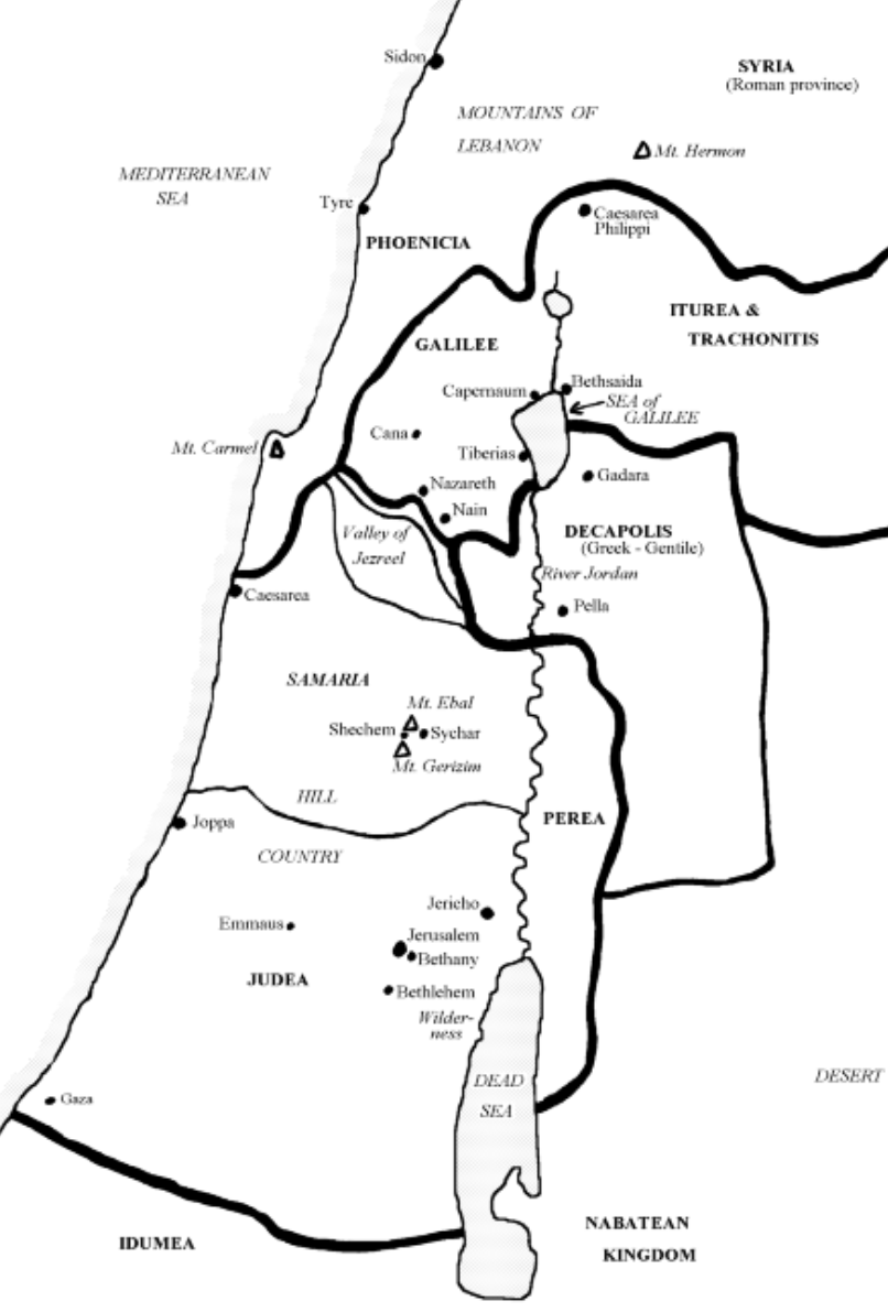
Idumea (Mk 3:8)
Idumea was directly south of Israel. The Edomites (descendants of Esau) were driven into southern Judea by Arabs (Nabateans). Idumea was conquered by Judas Maccabeus and John Hyrcanus (126 BC), who forced the inhabitants to become Jews and to be circumcised. Herod's family was from Idumea. Neither Idumea or the Nabatean kingdom were part of the Roman Empire.
Nabataean kingdom
The Nabataean kingdom was south-east of Israel. Arabs drove the Edomites out of Edom to Idumea around 300 BC, and founded the kingdom of Nabataea, with its capital at Petra. Neither Idumea or the Nabataean kingdom were part of the Roman Empire.
Perea, or Peraea
Lying directly east of the River Jordan in the Transjordan, in NT times, this was known as the ‘the land beyond the Jordan’ (Mk 3:8). It was a Greek speaking area, but also occupied by Jews and ruled by Herod Antipas.
Judea
This was roughly the same area as the old southern kingdom of Judah. The Roman province of Judea also included Samaria and Galilee. The main biblical places were Jerusalem, Jericho, Bethany, Bethlehem and Emmaus.
Samaria
This was roughly the same area as the old northern kingdom of Israel, and was populated by Samaritans. Sargon II of Assyria (721 BC) deported the people to Assyria and repopulated the area from other parts of the empire, to mix the populations. The religion was mixed, but similar to Israel. They had their own temple on Mt. Gerizim (Jn 4:20). They were rejected and hated by Jews, who referred to them as ‘the city of fools’ or ‘the foolish people who lived in Samaria’. Jews often travelled up the east side of the Jordan, to reach Galilee from Jerusalem to avoid passing through Samaria. The most important city in NT times was Caesarea, which was the official residence of the Herods and Roman procurators. It had an magnificent artificial harbour. Paul was held in prison here for two years (Acts 25). Inland was Sychar, where Jesus met the woman at the well (Jn 4). Shechem was an important road crossing point, between Mt. Ebal and Mt. Gerizim.
Decapolis
The Decapolis was an area consisting of ten towns in a trade and defence league in the Transjordan. It was Greek speaking, Gentile area. Legion the demoniac was from here (Mk 5). One of the main towns was Pella, to where the church fled from Jerusalem in AD 70.
Galilee
Galilee was the most fertile part of Israel. There was abundant oil, corn, flax, and excellent fruit. The cost of living was far less than in Judea. Galilee was also a centre for industry, including potteries, glass works, and dye-works.
A great road crossed through Galilee, an formed part of an international trading route. It ran from Damascus and the east, crossing the Jordan where it flows into the Sea of Galilee, over the ‘Bridge of Jacob’. Then it passed though Capernaum, Nazareth, to Ptolemais on the Coast. This road would continually be crowded with travellers and traders from many nations.
Many of the main settlements lay on the shores of the Sea of Galilee. Bethsaida (its name meaning ‘house of fishes’) was the location of several miracles performed by Jesus. Capernaum was where Jesus was based during his Galilean ministry. It was a large settlement on the north shore of the Sea of Galilee, and important for fishing. Magdala was on the western shore of the Sea of Galilee, and was known as the city of dyers. It was the home of Mary Magdalene (Mk 15:40, 16:1, Lk 8:2, Jn 20:1). Tiberius on the western shore of the Sea of Galilee was built in late first century BC, but had been built on the site of a graveyard, so Jews refused to live there. It was a splendid, but heathen city, with magnificent buildings. (Jn 6:1,23, 21:1), and home of Herod Antipas.
Cana was the birthplace of Nathanael (Jn 21:2), where Jesus turned the water into wine (Jn 2), and healed the official's son (Jn 4:46), the first two ‘signs’ in John's Gospel. Chorazin was well known for its grain.
Nain was one of the southernmost places in Galilee. Nazareth lay on the main trading route. It was home to one of the 24 courses of the priests, who would take turns to serve in the temple. The priests of each course would be gathered in certain towns, then travelled together to Jerusalem.
Phoenicia
Lying to the north of Israel, the Phoenicians were a great sea-faring people, from their cities of Tyre and Sidon.
Iturea and Trachonitis
Iturea and Trachonitis was the the area to the north and east of Bethsaida, including the town of Caesarea Philippi. It was an infertile and rocky, a perfect hideout for zealots. Herod Philip ruled over this area as tetrach.
Syria
To the north-east was Syria, which was a separate Roman province.
Travel in Israel
There were six main roads linking the main centres, particularly Caesarea, the military and political capital, with Jerusalem, the religious capital. There were also a multitude of secondary roads and tracks, passable only on foot or donkey.
A Roman mile (mille passus) was a unit of distance used to measure road distances. On Roman roads, each mile was marked with a mile-stone. It was equal to 1000 paces, or 5000 Roman feet. One Roman mile is about 1400m (1620 yards).
The southern road
This ran from Jerusalem to Hebron through Bethlehem. To the west it reached the coast at Gaza, and to the east, ran to Arabia and Damascus.
The coast road
This was the most important military highway stretching from Egypt to Tyre via Gaza, Ascalon, Jamnia, Lydda, Diospolis, Caesarea and Ptolemais. There was a branch from Lydda to Antipatris and Jerusalem, via either Emmaus or Beth-horon, which was a shorter route (Acts 23:31). Another branch from Tyre led to Caesarea Philippi and Damascus. Lydda to Antipatris was 20 Roman miles, Antipatris to Jerusalem was 50 Roman miles, and from Jerusalem to Caesarea was 78 Roman miles.
Jerusalem to Caesarea
This was the main road between Jerusalem and Caesarea. It passed through Beth-horon, Lydda and Joppa. Peter travelled along part of this road on his way to the house of Cornelius (Acts 10:23-24). Paul would have been taken along this road as a prisoner (Acts 23).
Galilee to Jerusalem
The main route between Galilee and Jerusalem passed through Samaria (Lk 9:53, 17:11, John 4). There was a branch at Shechem east to Damascus, and west to Caesarea.
Jerusalem to Galilee east of the Jordan
Jews wanting to avoid passing through Samaria would take this route from Jerusalem, passing through Bethany and Jericho, before fording the River Jordan, then passing through Perea to reach Galilee (Lk 10:30, 19:1,28, Mt 20:17,29).
Damascus to Rome
The international road to Rome from the east began at Damascus, and passed through Capernaum, Tiberias, Nain, Nazareth and Ptolemais, to reach Rome by sea. There was a branch at Nain leading to Samaria.
Related pages